
Golden Gate Dozen Trail

Meet the Golden Gate Dozen: a roughly 13-mile hike or bike ride that strings together 12 beloved national park sites in San Francisco into one unforgettable route, from Crissy Field to Fort Funston. It's the ultimate "wait, this is a national park?" day, with big views, beach breaks, and history hits baked into your everyday city loop. 

Want to go for all 12 at once, or tackle it in chunks? Check out the route map, and find full turn-by-turn directions below. Everybody should get a chance to participate in this stunning trail, so we've got some ideas for accessible options too. 

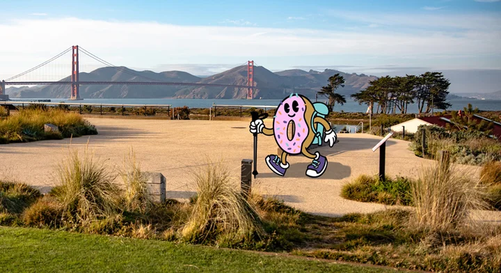
The Golden Gate Dozen reflects the Parks Conservancy's mission to connect people to parks and celebrate parks as everyday spaces. These national park sites are part of daily life in San Francisco, and we're proud to introduce a new reason to get out in parks, whether you're tackling the full route or quickly dipping into a favorite stretch

Great news for savvy parkgoers: The Golden Gate Dozen is highlighted on AllTrails, thanks to our partnership through the Public Lands Program. This collaboration helps spotlight the GGNRA and makes it even easier for people to discover and enjoy these national park sites. 
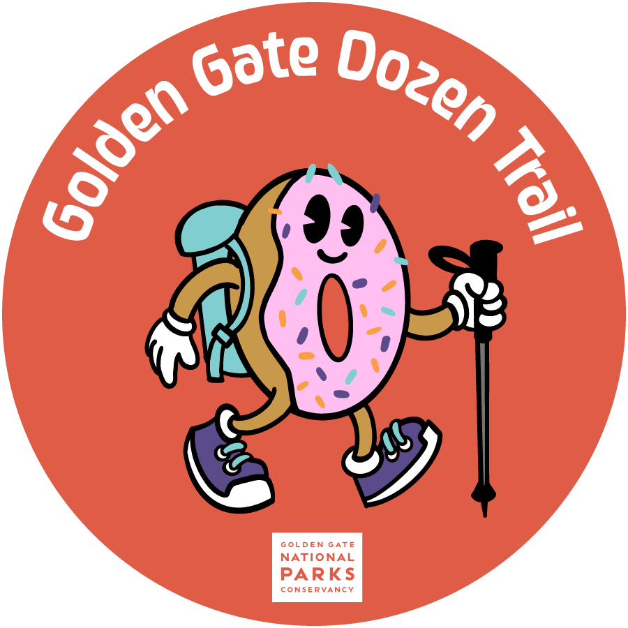
Highlights of the Golden Gate Dozen Trail

1. Crissy Field: Starting at the East Beach Parking lot, you can take a mostly flat stroll (or bike!) through the beautiful marshland—bring your binoculars for birdwatching.
 

2. Presidio Tunnel Tops: Stop by the Presidio Visitor Center to get a hat or jacket (depending on the weather) and then hit the food trucks and take in the iconic bridge views.  
 

3. Fort Point: This free historical site is FULL of interactive exhibits and has a unique vantage point under the Golden Gate Bridge. If you need a caffeine boost on the way, stop by the Warming Hut for a Crissy Mocha!
 

4. Golden Gate Bridge: Need we say anything about this site? Opt into crossing the Golden Gate, or make a quick stop at the Golden Gate Welcome Center and continue on the trail.
 

5. Baker Beach: Another iconic bridge-viewing site, if you're feeling like hitting the beach, head down the Sand Ladder.
 

6. The Presidio: Experience a new part of this historic military site by taking a quick detour on the Lobos Creek Valley Trail, a nature trail with deep info on native dune habitats.
 

7. China Beach: Enjoy this quieter park site, currently undergoing a transformation, and take in the view of the Marin Headlands across the water.
 

8. Lands End: Pop into the Lands End Lookout for some history of the area as an Ohlone fishing site and a place where John Harris fought for civil rights at your next destination.
 

9. Sutro Baths: Explore the ruins of the Sutro Baths, where San Franciscans once splashed in salt-water pools. A good place to pause and reflect before getting back on the trail.
 

10. Sutro Heights: Find the historic statues (shh, don't tell anybody they're replicas of Adolf Sutro's originals), and remains of the Parapet for views of your next destination.
 

11. Ocean Beach: A loooong stretch of gorgeous coastline. Keep an eye out for Snowy Plovers and give them a wide berth. 
 

12. Fort Funston: You made it! Reward yourself with a snack on the breathtaking bluffs, watch the hang gliders, and take in the fresh coastal air.

Park stops 1-2: Crissy Field to Presidio Tunnel Tops 

  • Start at the Crissy Field East Beach Parking Lot.
  • Head west along the Crissy Field Promenade. At the end of the parking lot, take a left, and find the trail that cuts diagonally through the East Bluff Picnic Area to the small bridge that crosses over Crissy Marsh.
  • Enjoy some birdwatching from the marsh!
  • Head west down Mason St., staying in the pedestrian lane of the sidewalk, and cross over Mason St. after the Crissy Field Center. 

Park stops 2-3: Presidio Tunnel Tops to Fort Point 

  • Enjoy the Outpost Playground and take a quick loop around Presidio Tunnel Tops if you have time and want spectacular, open views of the Golden Gate Bridge and Alcatraz Island.
  • Eventually make your way back toward the Outpost Meadow at the northwest side of Presidio Tunnel Tops and cross back over Mason St.
  • Take a right to hug Crissy Marsh and make your way back to the Crissy Field Promenade.
  • Take a left and follow the Crissy Field Promenade to the Warming Hut.
  • Stop at the Warming Hut for a Crissy Mocha or any other provisions you might need for the rest of the Golden Gate Dozen! Plus this is a great picture spot.
  • From the Warming Hut, continue left along the Crissy Field Promenade, which eventually turns into Marine Drive, follow that all the way to Fort Point National Historic Site. 

Park stops 3-4: Fort Point to the Golden Gate Bridge 

  • Well, you’re already right next to the bridge, so enjoy it for a moment. Take a tour of Fort Point or find Hopper’s Hands next to the Fort for a local’s treat. This is a great photo spot!
  • Head back down Marine Drive toward the Warming Hut, but before you get there, look for the steps of the Battery East Trail heading up the hill. There’s a sign that will point toward Battery East and the Golden Gate Bridge.
  • At the top of the steps, take a right to follow the Battery East Trail.
  • Keep heading toward the bridge by following either the Battery East Trail or the smaller trail that heads down toward a hidden picnic spot. Either way, rejoin the Battery East Trail and take a left to head up toward the Golden Gate Bridge Welcome Plaza.
  • This is a great place to stop and get a drink from Equator Coffees or find the hidden histories behind the bridge at the Golden Gate Bridge Welcome Center. 

Park stops 4-5: Golden Gate Bridge to Baker Beach 

  • Head back down to the Battery East Trail and take a left to swing under the bridge.
  • Follow the trail as it turns into the California Coastal Trail and heads up toward the Golden Gate Overlook.
  • This is another great photo spot if you want that “Golden Gate Bridge Between Two Trees” moment!
  • Get back on the California Coastal Trail as it follows Lincoln Blvd. for awhile.
  • If you’re up for a big challenge, swing down to the Batteries to Bluffs Trail, but this could add 30 minutes to an hour to your overall hike.
  • If sticking to the California Coastal Trail, you’ll be on it for about 20 minutes until you see the Sand Ladder turnoff. Ignore that unless you want more of a beachy experience.
  • After the Sand Ladder turnoff, follow the wider Coastal Trail as it veers off to the right down to Baker Beach. 

Park stops 5-6: Baker Beach to the Presidio 

  • Explore Battery Chamberlin and head south toward the Baker Beach parking lot. Follow the Coastal Trail past the first parking lot and through toward a second, smaller parking lot. Follow it again past that parking lot and around the fence. It will get sandy in this stretch!
  • At the end of Baker Beach, there’s a small staircase that heads up toward 25th Ave. in the Sea Cliff neighborhood, which will take you toward your next destination.
  • You’ve been in the Presidio this whole time, so make sure to count it as one of your Golden Gate Dozen! But if you want a true Presidio experience, we recommend taking a quick jaunt over to the Lobos Creek Valley Trail. From Baker Beach, take Gibson Rd. toward Bowley St. and cross over Lincoln to the Lobos Creek Valley Trail. This is a fun nature trail with deep info on native dune habitats. Then you can head back out to Lincoln St. And take a left to head toward the Sea Cliff neighborhood and rejoin the Golden Gate Dozen. This will add about 30-45 minutes to your route.  

Park stops 6-7: The Presidio to China Beach 

  • Follow 25th Ave. up to the left, then take a right at Sea Cliff Ave.
  • This is another small side-jaunt, but this will only take about 10 minutes: Follow Sea Cliff Ave. down to China Beach to see its fascinating history and hidden views of the Golden Gate Bridge and the ocean.
  • Get back on Sea Cliff Ave. and follow it as it becomes 29th and El Camino Del Mar. 

Park stops 7-8: China Beach to Lands End 

  • Follow El Camino Del Mar up toward Lincoln Park. Once you enter the park, take a right to get back on the California Coastal Trail.
  • Stop at the Eagle’s Point Overlook—now you’re just covering the bridge from every angle.
  • Get back on the Coastal Trail and follow it all the way through Lands End. This is the same path a railroad once carried people from downtown San Francisco all the way to the “outerlands” of Lands End. You’ll be on this trail all the way to the Lands End Lookout. 

Park stops 8-9: Lands End to Sutro Baths 

  • At the Lands End Lookout, you can learn some of the history of Sutro Baths. You might want to head down the stairs to check it out, or continue on your way.
  • Cross Pt. Lobos Ave. over to the Sutro Heights parking lot. Be careful crossing here, this is a busy road. 

Park stops 9-10: Sutro Baths to Sutro Heights 

  • Sutro, Sutro, Sutro! Sutro Heights was a public park built by Adolph Sutro for the people of San Francisco, and once housed an observation deck, gardens, and statues. The statues you see today are replicas of the originals. From the main trail, you can take a quick swing to the right to see the original Parapet area and those views of Ocean Beach.
  • Otherwise, follow the trail through Sutro Heights Park toward the southern end of the park, then down the hill toward Balboa St.  

Park stops 10-11: Sutro Heights to Ocean Beach 

  • Cross Great Highway at Balboa St to get over to Ocean Beach.
  • Settle in for the longest, flattest, sunset-iest portion of your trip, along Ocean Beach!
  • You can either walk along the beach itself, follow the Esplanade Trail, or jaunt up to the Sunset Dunes park. Either way, you’ll be following this portion for about 3 miles.
  • At the end of the Great Highway, turn left on Sloat Blvd. 

Park stops 11-12: Ocean Beach to Fort Funston 

  • You’re in the home stretch now! Follow Sloat Blvd. as it hugs the San Francisco Zoo on the right.
  • Continue following the Zoo by taking a right at Skyline Blvd.
  • At the Zoo Rd. intersection, cross over to the other side of Skyline Blvd. to find a more protected walking path.
  • Follow Skyline Blvd. south as it follows Lake Merced.
  • At the intersection with John Muir Dr., cross over to Fort Funston.
  • Technically you’ve reached your final destination! But if you want to explore Fort Funston, you’ve got some options. Head straight up the hill toward Battery Davis, or loop around on Fort Funston’s trails and enjoy some good dog-watching and hang gliders.
  • Congrats, you made it! Enjoy the triumph of knowing you got to 12 national park sites in one day. You’re now a Dozen-er! 

There are many ways to enjoy the Golden Gate Dozen, here are some ideas for people of all abilities along the trail: 

Biking the Golden Gate Dozen is a breeze! You can still hit all 12 park sites, with time in your day to spare. Here are turn-by-turn directions for biking the full route: 

  • Starting at Crissy Field East Beach, head out to the bike path along Mason St. and turn right. 
  • At the first major intersection with Crissy Field Ave., take a left and then a right to follow the bike-only segment up the hill toward Lincoln Blvd.
  • Follow the bike path along Lincoln Blvd. and hop onto the Battery East Trail as it veers off to the left, either right after Long Ave. or after the Battery East parking lot. 
  • Follow the Battery East Trail—stopping at the Golden Gate Bridge Welcome Plaza for an Equator Coffees if you like—around and under the bridge.
  • Follow the California Coastal Trail on the other side of the bridge, past the Golden Gate Overlook, to where the trail joins up with Lincoln Blvd. 
  • Follow the bike lane along Lincoln Blvd. After Washington Blvd., bikes merge with cars and it turns into a steep downhill portion all the way down to Baker Beach.
  • Stop and take a right to go into Baker Beach, or keep going by following Lincoln Blvd. as it turns into El Camino Del Mar in the Sea Cliff neighborhood. 
  • Where the road dead-ends, take a quick right to go down to China Beach, or a left to continue along El Camino Del Mar up to Lincoln Park.
  • You’ll have to miss the Lands End Trail portion of the Golden Gate Dozen, but you’ll get to see Lands End soon! Follow El Camino Del Mar up toward the Legion of Honor, taking a left at Legion of Honor Dr. and following that down to Clement St.
  • Take a right on Clement St. and follow it all the way as it becomes Seal Rock Dr. and you end up at Lands End.
  • Take a left at El Camino Del Mar and a quick right on Point Lobos Ave., stopping at Lands End Lookout along the way if you need a break.
  • Another big downhill as you follow Point Lobos Ave. past Sutro Baths and down toward Ocean Beach. 
  • Follow the bike lane along Ocean Beach to the Sunset Dunes parks, and enjoy the expansive views of the Pacific!
  • Take a left at Sloat Blvd. and follow it up to Skyline Blvd., taking a right to go around the Zoo.
  • The next stretch is tricky on a bike so stay vigilant, but there’s a small shoulder on Skyline Blvd., you can follow it all the way up to Fort Funston Rd., taking a right into Fort Funston.
  • Congrats, you just biked the Golden Gate Dozen and you, too, are a Dozen-er!