This short trail segment connects Rodeo Beach with Battery Alexander, one of five powerful batteries built by the U.S. Army around the turn of the 20th century. Those guns, manned by soldiers at nearby Fort Barry, were emblematic of the "Endicott Period" of coastal defense technology.
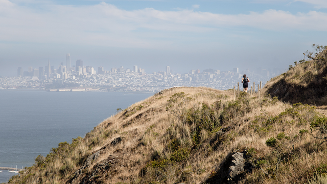
Slacker Hill Trail is a one-mile, moderately trafficked out and back trail located near Sausalito, California that offers scenic views and is rated as moderate. The trail offers a number of activity options and is accessible year-round.
Hiking up to the ridge promises a rewarding view. It is a steep trail, and descending down the gravel can be slippery and loose. This trail is not for the faint of heart. However, some of the most famous photos of the Golden Gate Bridge are taken from this ridge.
A hike along the SCA Trail will provide a breathless vista of the Golden Gate Bridge and the surrounding Bay. When the sun is shining and the fog is lifted, hiking along this trail will make memories that will last a lifetime.
This is another escape hatch into the wild beauty of Rancho Corral de Tierra. Park on Etheldore Street, and make your way up Ranch Road. Keep your eyes peeled for the trailhead to your left. Then begin your exploration in earnest, bearing northeast.
This short and simple trail is often overlooked, despite being a wonderful access trail that is sometimes utilized by cyclists coming out of the Tennessee Valley.
Plevin Cut is a hiking trail in Marin County, California. It is within Mount Tamalpais State Park. It is 0.2 miles long and begins at 482 feet altitude. Traveling the entire trail is 0.3 miles with a total elevation gain of 116 feet.
Picture just you, the chaparral, the crashing waves, the sky, and a trail that runs along the rugged coast just south of Muir Beach. The Pirate's Cove Trail is probably what you've been imagining.
This trail provides views above the fog, and connects to a short out and back or numerous other trails, for loops down into the valley below. Overlooking the Muir Woods National Monument and the Pacific Coast, the vistas are breathtaking. Look for the Farallon Islands, ships passing by, and more.
Best used in the downhill, northerly direction into Tennessee Valley. From the junction with the Miwok Trail - Bunker Road to Wolf Ridge, the trail starts fairly level, crossing several wood bridges with nice views over Tennessee Valley out to the Pacific Ocean.