Aggregate/Gravel

Trail
Length
2.59 miles round-trip
A nice breeze will be at your back most days. This trail connects to the top of the eastern ridge. Near the top are some easily avoidable ruts. You'll get ocean and beach views if you turn around and look back. It never gets too steep. Near the upper end,...

Trail
Length
1.57 miles round-trip
Don't miss the short journey up to the Sweeney Meadow. While it can be a bit of effort to reach the Sweeney Ridge , it's well worth it. Visitors will enjoy passing wildflowers in spring and will also be treated to great views. This trail is part of an easy...

Trail
Length
0.16 miles round-trip
This is a short and steep downhill that brings you from 48th Ave down to Balboa Street. The path has a few steep steps built into the hillside which makes the difficulty Intermediate/Difficult. This path goes from Ocean Beach up to Sutro Heights Park and back.

Trail
Length
1.03 miles round-trip
Slacker Hill Trail is a one-mile, moderately trafficked out and back trail located near Sausalito, California that offers scenic views and is rated as moderate. The trail offers a number of activity options and is accessible year-round.

Trail
Length
1.39 miles round-trip
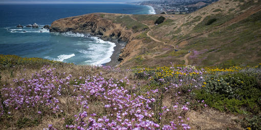
The Rodeo Avenue Trail begins with a series of switchbacks. It seems that every time you come around one of these turns you are looking at a different forest. Eucalyptus, tall and full, then the yellow Acacia followed immediately by the cypress grove and near the top, a mix of...

Trail
Length
2.61 miles round-trip
Best used in the downhill, northerly direction into Tennessee Valley . From the junction with the Miwok Trail - Bunker Road to Wolf Ridge, the trail starts fairly level, crossing several wood bridges with nice views over Tennessee Valley out to the Pacific Ocean. Dropping from the ridge, it gets...

Trail
Length
2.10 miles round-trip
From Skyline College, you'll be shocked by how quickly you can leave civilization. Begin the climb through the trees to a view of Rockaway Beach. You'll have some great ocean views during this portion of the trail. The trail turns away from the ocean, and you view the valley below...
Trail
Length
0.23 miles round-trip
At the west end of the Old Mori Road Trail, you'll come to Mori Point 's famous Bootlegger's Steps. Although the steep staircase looks daunting, take a deep breath and charge (or chug) up the bluff to the Mori Headlands Trail, where you'll be rewarded with spectacular views of the...

Trail
Length
0.44 miles round-trip
At the end of the Old Mori Road Trail, at the west end of Mori Point , you'll come to the intimidating sight of the Bootlegger's Steps. If you can, take a deep breath and power through, because you'll be rewarded at the top with a seascape to rival the...

Trail
Length
1.58 miles round-trip
This is a wide open pathway that gives access to bunkers, cliffs, beach, crashing waves and views in all directions. At the end, there is a little loop that looks down to the Rodeo Lagoon and Cronkhite Beach. Take the dog, let the kids explore, picnic, be in the wind...